


Using ground-based GPS to characterize atmospheric turbulence
Full citation:
Hill, E. M., J. L. Davis, P. Elósegui, B. P. Wernicke, E. Malikowski, and N. A. Niemi (2009), Characterization of site-specific GPS errors using a short-baseline network of braced monuments at Yucca Mountain, southern Nevada, J. Geophys. Res., 114, B11402, doi:10.1029/2008JB006027.
Abstract
A new method for measuring and studying atmospheric turbulence is presented. The method uses data from a local network of GPS receivers. The GPS data are processed in a way that assures that the estimated zenith total delays (ZTD) contain the effects of atmospheric turbulence present in the GPS observations. The turbulence is characterized using the spatial structure function for the atmospheric zenith total delay. The structure function is modeled by an expression with unknown parameters which contains information about the turbulence. The unknown parameters are solved by a fit to the observed ZTD variations. We apply the method to GPS data from the Yucca Mountain network, Nevada, USA. The results show that the magnitude of the turbulent variations in that region have a strong seasonal dependence, with much larger variations in summer compared to winter.
Figures
High resolution images may be obtained by clicking the link above.
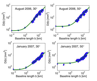
Figure 1.
Structure functions D(b) (equation (2)) as a function of baseline length, as estimated by the GPS data. Two one-month periods are shown: (top) August 2006 and (bottom) January 2007. (left) Results using an elevation angle cut-off of 30° and (right) results with an elevation angle cut-off of 50°. Also shown are also the fits to equation (3) (green lines).
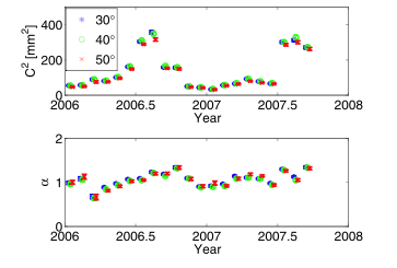
Figure 2.
Parameters C2 and a (equation (3)) estimated from the GPS data for the years 2006 and 2007.
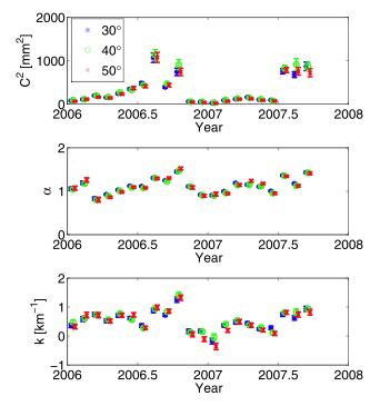
Figure 3.
Parameters C, a and k (equation (4)) estimated from the GPS data for the years 2006 and 2007.