
CURRENT PROJECTS
- Antenna Multipath Calibration System
- Atlantic Mediterranean Interdisciplinary GPS
- Atmospheric Structure and Dynamics
- Basin and Range Geodetic Network
- BIFROST Fennoscandian GPS Network
- EPS 206
- Project ATLAS
- Sea Level
- Western U.S. Cordillera Deformation Field
LINKS
Western U.S. Cordillera (WUSC) Deformation Project
The objective of the Smithsonian Astrophysical Observatory's WUSC Deformation Project is to determine the full spectrum of crustal deformations associated with active geodynamic processes in the western United States by linking existing geodetic networks throughout this diffusely deforming continental region, and to assist the geo-scientific community by providing useful data products derived from the aggregate geodetic network.
Funding
Funding for this project has been provided by the National Science Foundation (NSF), the Department of Energy (DOE), National Geodetic Survey (NGS), the US Geological Survey (USGS), National Aeronautics and Space Administration (NASA), and the Smithsonian Institution. Dissemination of this information was funded in part by the Atherton Seidell Endowment Fund of the Smithsonian Institution.
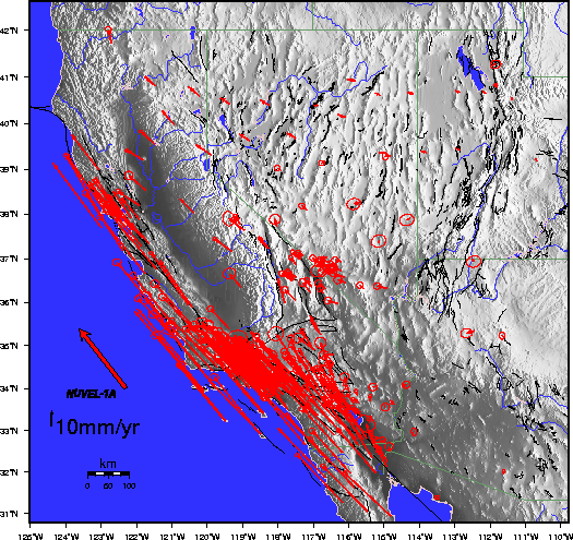
Estimates of horizontal velocity (red arrows) relative to the North America plate. Error ellipses represent the 95% confidence level. Thin black lines represent mapped Quaternary faults. Also shown for reference is the NUVEL-1A estimate for Pacific-North America relative plate motion.
For further information contact:
WUSC Questions
Harvard-Smithsonian Center for Astrophysics
60 Garden St, MS 42
Cambridge, MA 02138-1516
(617) 496-7811
![]()
For questions or comments on web site contact: Geodesy Webmaster
Document URL: lweb.cfa.harvard.edu/space_geodesy/WUSC/index.html
Last Modified: Friday, 11-Mar-2005 12:36:40 EST