
CURRENT PROJECTS
- Antenna Multipath Calibration System
- Atlantic Mediterranean Interdisciplinary GPS
- Atmospheric Structure and Dynamics
- Basin and Range Geodetic Network
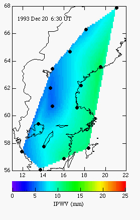
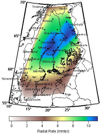
- BIFROST Fennoscandian GPS Network
The BIFROST Project
BIFROST (Baseline Inferences for Fennoscandian Rebound, Sea-level, and Tectonics) involves investigators from the Harvard-Smithsonian Center for Astrophysics, the Onsala Space Observatory, the University of Toronto, the Swedish National Land Survey, and the Finnish Geodetic Institute. The purpose of BIFROST is to use the Global Positioning System (GPS) to measure crustal deformation in Fennoscandia for geodynamic, sea-level, and tectonic studies. Measurements were begun in August 1993.
For further information contact:
James Davis
Harvard-Smithsonian Center for Astrophysics
60 Garden St, MS 42
Cambridge, MA 02138-1516
(617) 496-7811
![]()
Document URI: /space_geodesy/BIFROST/index.html
Server Name: lweb.cfa.harvard.edu
Last Modified: Friday, 17-Jun-2005 11:36:40 EDT
Server Admin: www-admin@cfa.harvard.edu