
The rocky surface, or lithosphere, of Earth—that part of our planet most familiar to us—is interesting not only because we live on it, but also aesthetically given its sheer beauty and scientifically given its occasional activity. Earth is geologically alive. Its interior boils and its surface erupts. Change still affects our home in space.
Active Sites Volcanoes are especially clear indicators of lithospheric activity—sites where molten rock and hot ash upwell through fissures or cracks in the surface. Despite their scarcity nowadays—rare, yet sensational, enough for them the lead news broadcasts—volanoes are examples of present-day activity, as are earthquakes that regularly occur when Earth’s crust suddenly dislodges under great stress (Figure 4.13). Tracing events backwards, geological studies of rocks, lava, and related substrata imply that surface activity must have been much more frequent, and probably a good deal more violent, long ago.
| FIGURE 4.13 — A volcano on Mount Kilauea in Hawaii and an earthquake in Kobe, Japan, display much tectonic activity. Kilauea (left) is an episodically ongoing eruption, whereas earthquakes are more rapid events, such as the one here (right) that killed >5000 people in 1995. (NOAA/World Wide) |
Figure 4.14(a) shows huge slabs of Canadian rock laying side by side yet differing in age by well more than a billion years; their juxtaposition alleges some large-scale jostling of surface rock. Figure 4.14(b) shows cliffs along the coast of Scotland displaying evidence for horizontally layered rock much as expected from millennia of sedimentary buildup on the ocean floor, yet above it lies nearly vertically layered rock; apparently some type of surface upheaval thrust one part of this rocky cliff onto the other. Other examples abound for past activity at or near the surface of Earth, despite erosion by wind and water that has clearly wiped away much of the evidence for truly ancient events.
| FIGURE 4.14— Ancient surface activity is exemplified (left) along a crustal fracture near Hudson's Bay in Canada, where rock to the right of kilometer-long crack has been dated by radioactive methods to be nearly 3 billion years old, while rock to the left is hardly more than 1 billion years old. Likewise (right), along the coast of Scotland, some type of surface activity must have thrust one part of this rocky cliff up onto the other since the background strata are nearly vertical and the foreground horizontal. (CGS/BGS) |
A map of the most active current sites on Earth, such as Figure 4.15, shows them unevenly spread across our planet. Instead, those sites outline well-defined lines of action, or faults of weakness, where crustal rocks dislodge (as in earthquakes) or mantle rocks upwell (as in volcanoes). Nearly all these sites have experienced surface activity within the past century, some of them causing much damage and loss of lives. As demonstrated by the map, these sites are especially abundant along the west coast of the United States, throughout the Aleutian Islands off the coast of Alaska and continuing across the Japanese islands, down along the Andes Mountains, up through India, as well as throughout much of Turkey, Greece, and the Aegean Sea. Only a few decades ago did it become clear that these faults delineate about a dozen gigantic “plates” or slabs of Earth’s surface. They’re called plates because of their size and scale whose shape resembles an upside-down dish, their huge horizontal extent (typically thousands of kilometers across) usually dwarfing their vertical thickness (~100 km deep). Figure 4.16 is a schematic of some typical plates, and Figure 4.17 is an overhead image of one on Earth.
| FIGURE 4.15 — The many dots plotted here represent active sites where volcanoes or earthquakes occurred in the 20th century. Taken together, these sites outline the "plates" that drift around on the surface of our planet. Arrows show the general directions and magnitudes of the plate motions. (Prentice Hall) |
| FIGURE 4.16 — Physical dimensions of two typical plates, each having dimensions of ~20:1. |
 |
FIGURE 4.17 — This spacecraft photograph shows the subcontinent of India and much of the Indian Ocean. All this (and more) comprises the Indian Plate, which actually includes Australia as well much of the surrounding south seas. (NASA) |
Notable also on the map of Figure 4.15, one of the most prominent faults separates the North American Plate from the Eurasian Plate, continuing on down between the South American Plate and the African Plate. Throughout the midst of the entire Atlantic Ocean, and extending without interruption all the way from Scandinavia in the north to the latitude of Cape Horn in the south, is the Mid-Atlantic Ridge—a thin, almost continuously submerged fault rising above sea level only at the subcontinent of Iceland. This ridge is the best known and most impressive of many smaller cracks and underwater trenches discovered in recent years by miniature submarines deployed from oceanographic ships.
Surface Movement Startling when first realized but now reasonably well understood, the huge plates are slowing sliding around—literally drifting on the surface of our planet, hence the popular term continental drift. In doing so, the plate movements have created the surface mountains, the oceanic trenches, and many other large-scale features strewn across the face of planet Earth. The plate motions have in fact shaped the continents themselves, hence the official term, plate tectonics—derived from the word “architecture,” meaning to build or construct, in this case mountains and oceans via the movement of plates.
Not that the plates are moving fast, by any means. The ground beneath our feet rightly feels like terra firma. Though the plates are still now drifting billions of years after the hardening of Earth’s crust, they do so today at extremely slow rates. Typical velocities of the plates amount to <3 cm/year, or roughly the speed at which our fingernails grow. Still, even at this sluggish pace, each plate has had plenty of time to move large distances during Earth’s history. For example, a drift rate of only 2 cm/year could separate continents by ~4000 km over the course of 200 million years—which happens to be, not coincidentally, the width and age of the Atlantic Ocean. That’s surely a long time by human standards, but actually only ~5% of the age of Earth.
As the plates drift around, collisions are routine, with whole continents bumping into one another. Yet, unlike two automobiles that collide and then stop, the surface plates, being so massive, have enormous momentum. Not easily stopped, they just keep crunching into one another for thousands, if not millions, of years. The Himalayan mountain range, of which Mount Everest is a prominent member, is a good example of two plates colliding (Figure 4.18). Here, the Indian subcontinent is thrusting northward into the Eurasian landmass at an abnormally fast rate of ~5 cm/year, not only lifting the towering Himalayas but also buttressing the Tibetan Plateau even at the present time. This particular collision between continents has been underway for nearly the past 50 million years. The Rocky Mountains in the U.S. and Canada are another case of continental impact, as segments of the Japanese arc, which are part of the Pacific Plate, plowed eastward into North America (Figure 4.19). Together, two relatively old plates caused vast amounts of wreckage while reshaping the ruggedly young Rockies. By contrast, the rounded and heavily eroded Appalachians in the eastern U.S. exemplify tectonic events that culminated ~300 million years ago.
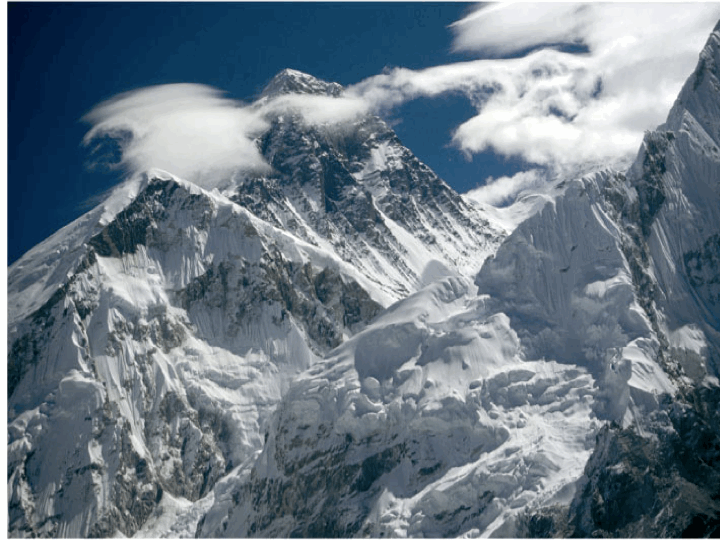 |
FIGURE 4.18 — Mountain building is largely caused by plate collisions, such as here when massive amounts of rock is uplifted on one side of Mount Everest, which is only a small part of the entire Himalayan mountain range midway between India and Central Asia. (National Geographic) |
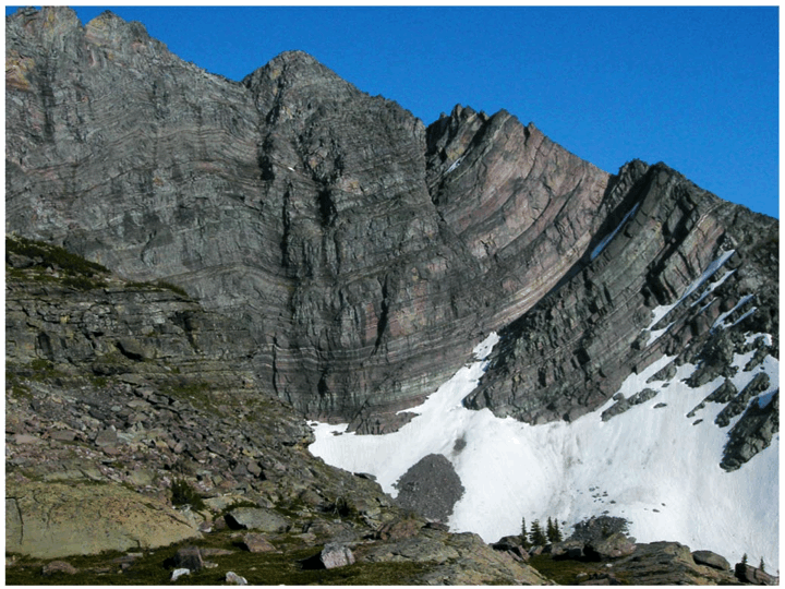 |
FIGURE 4.19 — Folding and jostling of rock is visible high in the northern Rockies, a mountain range upthrust about 70 million years ago. For scale, note at bottom right the evergreen trees, which are about 10 meters tall. (Megan Chaisson) |
Some plates contain no large continent, others no continent at all. For example, the southeastern part of the Pacific area, called the Nazca Plate, has no land mass. Accordingly, as depicted in Figure 4.20, its seafloor crust rides much lower than the west coast of continental South America, causing it to slide beneath the South American Plate. The interface between these two plates is a well-known site of much geological activity, the region even today being plagued by many earthquakes. Evidently, two gigantic plates cannot easily slip by one another, even if one lacks a continent. Although no observational data yet prove it, circumstantial evidence strongly suggests that the crust of the Nazca Plate is thrusting downward—"subducting"—into the mantle, while the South American Plate overrides Nazca and is slightly uplifted. This, then, is another way that mountain chains are built—in this case, the Andes Mountains all along the west coast of South America.
| FIGURE 4.20 — The southeastern part of the Pacific area—called the Nazca Plate—is apparently being overrun by the western part of the South American Plate. As a result, the Nazca Plate is diving into the mantle, while uplifting the Andes Mountains along the western edge of the South American Plate. |
Not all plates experience head-on collisions. As noted by the arrows of Figure 4.21, many slide or sheer past one another. The most famous active region in North America, the San Andreas Fault in California, serves to illustrate this kind of less severe plate interaction. This fault causes much earthquake activity as the Pacific and North American plates rub past each other. The two plates are not quite moving in the same direction and not quite at the same speed. Though they surely are in contact, like a poorly oiled machine their motions aren’t steady and smooth. Rather, jerky and sudden movements result each time the pressure to drift overwhelms the friction to stay put.
 |
FIGURE 4.21 — The San Andreas Fault (in red) results from the North American and Pacific plates sliding roughly past one another (a). The fault line separating the two plates can be seen clearly in high-altitude photographs (b) of the San Francisco Bay area. (Prentice Hall/NASA) |
Evidence of Tectonics Several strands of evidence support the idea of plate tectonics on Earth, the most obvious provided by the subject of geography. Just looking at a map of Earth’s major continents, such as in Figure 4.22, we readily see that they seem to fit together like pieces of a puzzle, especially the facing coastlines of Africa and South America. The easternmost Brazilian coast meshes nicely with the Ivory Coast of Africa and its armpit near Nigeria. Farther north, west Africa fits nicely into the oceanic cavity in the Caribbean Sea and the Gulf of Mexico. Farther south, southwest Africa matches up with the southern coast of Brazil, Uruguay, and Argentina. Admittedly, the fit is less good in the northern hemisphere, given the “debris” in the North Atlantic, including Iceland, Greenland, and the British lsles. Yet the western coast of Europe nestles nicely with the Mid-Atlantic and New England coastlines of North America. Furthermore, rock formations all along both sides of the Atlantic are very much the same.
| FIGURE 4.22 — Given the currently estimated drift rates and directions of the plates, we can trace their movements back into the past. About 200 million years ago, they would have been at the approximate positions shown in (b). The continents' current positions are shown in (a). |
Apparently, a gargantuan landmass must have dominated our planet sometime in the past. Knowing the plate vectors (both direction and magnitude of drift), geologists can trace their movements back into the past. (It’s not too different from measuring the speeds of galaxies receding and then mentally reversing them to model the early Universe, or reconstructing an automobile accident by studying the scattered wreckage.) And what they’ve found is evidence for a single ancestral supercontinent, called Pangaea and meaning “all lands,” that must have contained almost the entirety of dry land on Earth. To the north was Laurasia and to the south Gondwana, each separated by a V-shaped body of water called the Sea of Tethys. The rest of the planet must have been completely covered with water.
Exactly when did Pangaea exist? The current locations of the continents, along with their estimated drift rates, imply that it must have been the major land feature on Earth ~200 million years ago. Dinosaurs, which were then the dominant form of life, could have sauntered from Russia to Texas via Boston without getting their feet wet. About 20 million years thereafter, Gondwana and Laurasia began dividing for reasons unknown, probably near present-day Gulf of Mexico. About 30 million years after that—namely, ~150 million years ago—Gondwana itself broke into various pieces: South America, Africa, and Australia, as we now know them. Shortly thereafter, Laurasia split, perhaps more violently, thereby producing North America, Europe, and the smaller fragments now in the North Atlantic Ocean.
The existence of such an ancient supercontinent and its subsequent breakup explain several heretofore peculiar findings. For example, when climbers first reached the summit of Everest ~50 years ago, they discovered fossils of fish and old clamshells. Only plate tectonics can seemingly justify how marine fossils could get lifted to nearly the highest point on Earth. Whatever caused Pangaea to come apart also set its continental fragments in motion. In particular, as India began its slow trek northward across the Sea of Tethys, fossils of marine life deposited at the bottom of that ancient sea were apparently pushed up alongside parts of the Eurasian landmass to form the Himalayas.
Plate tectonics have slowly reshaped the surface of our planet. In some cases, the seafloor has been literally thrust up to the top of the world. In other cases, huge underwater mountain ranges have slowly emerged. In still others, entire subcontinents have apparently submerged. As humankind begins its in-depth exploration of the nearby planets, it will be interesting to see if those alien worlds were similarly reshaped so heavily by physical events that went far beyond mere surface erosion. So far, we think not, as noted later in this PLANETARY EPOCH.
To give credit where credit is due, much of this geographical puzzle was solved early in the 20th century by the German meteorologist Alfred Wegener, but few believed him. The idea that huge slabs of rocky crust could be literally drifting around on the surface of Earth was preposterous until the 1960s. Views changed rapidly, however, when several additional lines of evidence suddenly became available. In the mid-1960s, academic geologists who championed continental drift couldn’t possibly have gotten tenure, whereas by the early-1970s those who didn’t couldn’t.
The subject of paleontology—the study of the fossilized remains of dead organisms (the Greek prefix paleo meaning old)—further bolsters the idea of plate tectonics. For example, fossils of Mesosaurus—a fresh-water reptile that lived nearly 300 million years ago yet has been extinct for the past 200 million years and is reconstructed in the sketch of Figure 4.23—have been uncovered at only two locations on Earth. One place is a small part of what is now the northeast Brazilian coast, while the other is on the west coast of Africa near present-day Ghana. These two places are precisely where the continents would have dovetailed on the ancestral supercontinent of Pangaea. If Africa and South America were always separated by the great expanse of the Atlantic Ocean, these reptilian creatures could have hardly survived the long swim between coasts. Even if they did, the chances are slim that they would have departed and landed at exactly those parts of the two continents that geographically mesh. A more reasonable judgment is that Africa and South America were once joined and that this reptile lived in a small region in the midst of Gondwana. Likewise, fossils of identical snails turn up in New England and Scandinavia and those of marsupials on the west coast of South America and eastern Australia—in both cases, among other examples, animals that could not have swum across such wide and open oceans.
| FIGURE 4.23 — Fossilized remains of a Mesozoic reptile (a) have been found at only two places on Earth: on the east coast of Brazil and on the west coast of Africa (b), just where the shading suggests the two continents overlapped ~200 million years ago. (Prentice Hall) |
A third piece of evidence for plate tectonics comes from oceanography—the study of ocean dynamics and history, as well as its physical and chemical behavior. Many of the active sites submerged beneath the ocean form a giant system of undersea cracks—the Mid-Atlantic Ridge being the most prominent example, stretching for ~15,000 km right down the middle of today’s Atlantic Ocean. Not only have underwater cameras lowered from surface ships mapped this vast fault, but robot submarines have also managed to retrieve samples of ocean floor at various places on both sides of its submerged mountain range. And what they found, as sketched in Figure 4.24, is that matter on the ocean floor closest to the underwater ridge is relatively young whereas that farther away is noticeably older.
| FIGURE 4.24 — Samples of ocean floor retrieved by oceanographic vessels are youngest close to the Mid-Atlantic Ridge and progressively older farther away. (Prentice Hall) |
These observations support the notion that hot matter upwells from cracks all along the Mid-Atlantic Ridge. In this way, some of the plates are literally pushed apart. The North and South American plates are moving generally westward while the Eurasian and African plates drift eastward—which is exactly the trend implied by the geographical fit noted above: The plates on both sides of the Atlantic Ocean have presumably been separating for the past 200 million years. To be sure, oceanographers have never found any part of the Atlantic seafloor to be older than this date. Submerged rocks close to the east coast of the Americas and the west coast of Europe and Africa are radioactively dated to be ~180 million years old; those closest to the Mid-Atlantic Ridge are only ~3 million years old.
Finally, a fourth bit of evidence also favors the idea of plate tectonics, although here the data aren’t as robust, their implications not as clear. This evidence is supplied by paleomagnetism—the study of ancient magnetism. Everyday experience tells us that iron is magnetic; in fact, any metal containing even small amounts of iron ore is usually magnetized. However, when iron is heated to temperatures ~1000 K, it loses its magnetic properties as individual atoms jostle freely (which is why magnetic thermometers often fall off the side of a roaring wood stove). Hot basalt—the dark, dense stuff of volcanoes—impregnated with traces of iron and upwelling from cracks in the oceanic ridges, is thus not magnetic. As the basalt cools, magnetism sets in as each iron atom effectively responds to Earth’s magnetic field like a compass needle. When the basalt solidifies to form hard rock shortly thereafter, it fixes the orientation of the embedded iron, since the iron atoms align themselves with the orientation of Earth’s field at the time of cooling. Accordingly, the ocean-floor matter has preserved within it a history of Earth’s magnetism.
Consider the Mid-Atlantic Ridge again. When samples of ocean floor are examined from sites close to the ridge, as sketched in Figure 4.25, the iron deposits are aligned with today’s north-south field. This is the “young” basalt that upwelled in recent times. Samples retrieved far from the ridge, however, often have their iron deposits misaligned at odd angles relative to the usual north-south field. This is the “older” basalt that upwelled in earlier times and was then subject to the twisting, turning, and drifting of nearby plates ever since. Working backward, oceanographers use the embedded iron to infer the past positions of the plates, as well as the north and south poles. Much like reorienting giant, mobile pieces of a very large jigsaw puzzle, they realign parts of the ocean floor to a common north-south direction and thereby infer the approximate drifts of the plates during the past 200 million years. When this is done, these paleomagnetic data also tend to support the existence of a single ancestral supercontinent on our planet.
 |
FIGURE 4.25 — Samples of basalt retrieved from the ocean floor often show Earth's magnetism to have been oriented differently from the current north-south magnetic field. |
Magnetic Field Reversals Paleomagnetic studies have advanced some remarkable additional findings in recent decades, all the while spawning yet another rich interdisciplinary interaction—this one between geology and astronomy, and possibly biology too. Foremost among these findings is the discovery that Earth’s north and south poles have flip-flopped many times over the years. Surprising as it sounds, the north magnetic pole, now in the Arctic region, has occasionally been in the Antarctic region, while the south magnetic pole has sometimes resided where what we now call terrestrial north. Such back and forth reversals have occurred irregularly hundreds of times during the past 200 million years and possibly thousands of times before that. Although not a frequent happening on human timescales, magnetic reversals have nonetheless occurred at least a dozen times in only the past 10 million years. The north magnetic pole has been in the Arctic region for the past 700,000 years—currently ~1000 km west of true geographic north, on Canada’s Prince of Wales Island. During the 20th century alone, Earth’s global magnetic field decreased several percent, perhaps presaging another dramatic reversal in the upcoming millennium.
These facts we know from seafloor samples dredged up from near the Mid-Atlantic Ridge, as shown in Figure 4.26. Since oceanographers date the seafloor according to its distance to the east and west of the ridge, samples tested for magnetism mark when Earth’s field changed its orientation. The seafloor resembles a giant tape recorder, with matter flowing from the central ridge to either side and laying down a record that is progressively older farther away. Hot matter first upwells through cracks in the ridge, after which it quickly cools, solidifies, and aligns trapped iron ore, preserving a record of Earth’s magnetism at that time. The matter then spreads out from the ridge while pushing apart the plates. In this way, the underwater data reveal a history of the Atlantic Ocean’s formation, growth, and alternating magnetism.
| FIGURE 4.26 — An entire series of alternately magnetised matter roughly parallels the Mid-Atlantic Ridge. In this simplified diagram, shading designates north-south orientation as we know Earth's magnetic field today, unshading the opposite orientation. (Prentice Hall) |
What could have caused such global reversals of Earth’s magnetism? While researchers don’t yet know for sure, apparently something occasionally upsets the steady spin of our planet’s liquid iron-nickel core. The metal core is the probable source of our planet’s magnetism—a geodynamo whose spin of an electrically conducting metal induces a magnetic field much like any electromagnet. Speculation has it that the culprit might be an inherent, convective instability in the usual rotation rate of the core, or perhaps even something more dramatic, such as collisions of Earth with cosmic objects like comets or asteroids. Such catastrophic events could upset the core’s spin by sloshing around the liquid trapped there, thus playing havoc with the normal field and setting the stage for it to change.
Whatever their cause, magnetic reversals aren’t likely instantaneous events. Some time is probably needed for magnetism to weaken gradually and finally dissipate. Likewise, some additional time—perhaps on the order of hundreds, even thousands, of years—might be needed for the magnetic field to become reestablished. If so, then each time a reversal occurs, the magnetosphere (including the Van Allen belts) far above Earth’s surface disappears, perhaps for a rather long time by any living standard. Without this protective “umbrella” to deflect or trap the charged cosmic-ray particles incident on our planet, biological systems might be harmed.
Circumstantial evidence argues for life having been threatened in this way in the past. Fossil records of ancient life forms show that, every so often, once-abundant plants and animals suddenly became extinct. No one knows why they perished so rapidly and in the BIOLOGICAL EPOCH we shall note some alternative ideas. Even the dinosaurs, which reigned supreme on our planet ~100 million years ago, seem to have vanished within a relatively short period of time. Asteroid impacts might well have triggered mass extinctions of living systems, but their ramifications likely included, in addition to climate and sea level changes, magnetic-field reversals. Some analyses of seafloor matter, though controversial, do imply a connection between the extinction of certain species of life and a reversal of Earth’s magnetism. Magnetic turnabouts are possibly death sentences for some species, yet therein lies a positive note as well: Other fossils found within the seafloor samples also show that whole new species emerged.
No one knows for sure what effect magnetic-field reversals have had (or might yet have) on the surface of our planet. But a general consensus seems at hand: While Earth’s magnetosphere is collapsed, the influx of high-energy particles (mostly from the Sun) would likely destroy the ozone layer and increase the amount of radioactive atoms in our atmosphere. These atoms would then be absorbed by plants and in turn eaten by animals, including humans. Although higher levels of radiation affecting plants and animals are unlikely to kill any life directly (for the atmosphere does also provide robust protection), cancerous cells would surely increase and the normal course of biological evolution would be disrupted. Some basic biological molecules, including genes, would suffer damage, causing reproductive errors, or mutations, from generation to generation in some living systems.
Contrary to popular belief, however, not all mutations are bad. Some are beneficial, enabling life forms to adapt better to changing Earthly environments—in short, to evolve. Mutations act as a motor of evolution and without them life wouldn’t have complexified so rapidly, as we shall see in the sixth, BIOLOGICAL EPOCH. And when the magnetosphere temporarily shuts down, that motor apparently accelerates.
We shall also come to realize later along the arrow of time that whatever species dominates life at any given period does so largely because that species enjoys a nearly optimum relationship with its environment. It’s best suited for its natural surroundings, enabling it to survive, and sometimes thrive, quite nicely. An analogy might be a well-focused image illuminated through a slide projector. A mutation (or a slight change of the slide’s focus) is likely to harm the dominant species (or the quality of the projected image). By contrast, lesser species (or slides out of focus) might profit from a period of increased mutations (or slide adjustments) by finding themselves bettered. At any one time, it is the dominant species that is most likely to change for the worse. Humans are now the dominant species on Earth.
Mantle Convection The Atlantic seafloor is still growing, pushing apart the North American and Eurasian plates, as well as the South American and African plates. Submarine expeditions prove that the Mid-Atlantic Ridge remains active, with hot basalt now rising through fissures and cracks encircling the globe for thousands of kilometers like seams on a giant baseball. Geologists assume that other plates on Earth’s surface are also pushed around by matter upwelling from similar, yet only partially explored oceanic ridges. Oceanographers are now retrieving and studying rock samples from the bottom of the Pacific Ocean and Caribbean Sea, among other places where seafloor activity is exposed. During the upcoming decades, we should gain a better understanding of all the major underwater cracks through which hot matter oozes from Earth’s interior.
We thus confront a central question of modern planetology: What drives the plates, however slowly they drift across our planet? In other words, what’s the source of the seafloor spreading? Answers all point to the mechanism of convection—basically, the upward transfer of subterranean heat via circulation—in this case, giant cyclical patterns of molten matter in Earth’s mantle. The conditions are perfect for this kind of physical process, which amateur geologist James Hutton foresaw >200 years ago yet found few adherents until a generation ago partly because he was such a poor communicator of science.
Here’s what we know today, a stance geared to Figure 4.27: The ocean floor is covered with a layer of sediment—dirt, sand, and dead marine organisms that have fallen through the seawater for millions of years. Below that sediment lies ~50 km of mostly granite, the low-density rock comprising the continents. Deeper still lies the mantle made of warm, partially molten basalt. And beneath that is Earth’s core, whose temperature of ~5000 K nearly equals that of the Sun’s surface! This is indeed the perfect setting for convection: Warm matter underlying cool matter. The warm basalt wants to rise, just like hot air in our atmosphere or smoke from a fire. It does so through any cracks and faults in the largely granitic crust. Every so often, such a fissure opens in the midst of a continental landmass, producing a spectacular volcano such as Mount Etna in Sicily or a geyser like that at Yellowstone National Park in Wyoming. However, most of the major crustal faults now known are submerged below water, probably for the simple reason that nearly 3/4 of Earth’s surface is covered by water. The Mid-Atlantic Ridge is the premier example, yet even this long and impressive suboceanic system is only part of a 60,000-km-long submerged mountain chain that formed in progressive stages by the breakup of previously intact continents.
| FIGURE 4.27 — Plate drift is probably caused by convection—in this case giant circulation patterns in the upper mantle. (Prentice Hall) |
Not all the warm basalt in the mantle can squeeze through the cracks and fissures. Some gets pushed back down. In this way, ascending and descending matter form huge circulation patterns within the upper mantle. These convective cycles often extend as much as ~1000 km below the crust, or nearly 20% of the way toward Earth’s center. They are also very sluggish, flowing at speeds of only ~3 cm/year and taking perhaps millions of years to complete a single cycle. The basalt slowly circulating below a crack is, after all, a semi-solid resembling warm asphalt, and moving much less smoothly than hot gas in the air or liquid in a pot of boiling water. The result is that the upwelling matter eventually spreads out horizontally in the upper mantle, thereby exerting enormous drag (frictional force) on the thin and crusty surface plates, causing them to slide across the face of our planet.
Much of Earth, then, acts like an engine—a heat engine that obeys thermodynamic laws. And the key to any such thermal device is a temperature gradient. Accordingly, energy naturally flows from hot to cold, that is, from inside to outside of any planet. Convective cycling allows Earth to cool and lose its heat to space in the fastest possible manner. Since rocks conduct heat so poorly—feel the cool bottom of a thin, blistering flagstone on a hot, sunny day—conduction of energy is not an option. In other words, tectonics is the most efficient way to remove internal heat by recycling rock from the interior to the surface over and over. In that way, Nature quite naturally seeks to destroy all gradients, namely, to even everything out and to attain the lowest possible energy state represented by a true equilibrium, at which time—surely billions of years into the future—planetary evolution will end.
Future Drifts Where are the plates headed? Assuming that warm basalt continues to rise through the fissures and thereby power the plates on their steadfast journeys, can we predict the positions of the giant landmasses on Earth in the relatively near future? By extrapolating the plate’s current vectors—again, both magnitude and direction of their drifts—geologists can reasonably anticipate where the continents will be in the years ahead, such as that suggested in Figure 4.28. For example, in ~50 million years, the Atlantic Ocean will have widened nearly another 1000 km. By contrast, the Pacific Ocean will have shrunk considerably; there being no large landmass on the Pacific Plate, this oceanic plate will presumably continue to be overridden by other continental plates such as the westward-moving South American Plate. Australia, which is actually part of the Indian Plate and moving fastest of all the plates at nearly 8 cm/year, will continue its northerly motion toward the Eurasian landmass, destined for a massive collision and truly renewed landscape in South Asia several million years hence. India itself will continue to thrust northward, as now, building the Himalayas to possibly greater heights. The Mediterranean Sea is doomed given the African Plate’s northerly motion, at the same time guaranteeing great skiing in the Alps for millions of years (provided that the climate doesn’t change much). And southern California, as part of the Pacific Plate, will be torn away from the North American Plate, with Los Angeles becoming a suburb of San Francisco in ~20 million years, before being dumped into the Aleutian Trench ~50 million years in the future.
| FIGURE 4.28 — A prediction of where the plates will have carried the continents of our planet ~50 million years from now. The dashed contours outline the continents' current positions. (Prentice Hall) |